Board index ‹ FlightGear ‹ Development ‹ Spaceflight
Earthview - an orbital terrain rendering engine [v2.0]
Re: Earthview - an orbital terrain rendering engine [v0.1]
![]() by rominet » Fri Oct 28, 2016 10:30 am
by rominet » Fri Oct 28, 2016 10:30 am
This is beautiful!
- rominet
- Posts: 605
- Joined: Sat Nov 01, 2014 2:33 pm
- Callsign: F-KATS
- Version: Git next
- OS: Debian GNU/Linux
Re: Earthview - an orbital terrain rendering engine [v0.1]
![]() by Johan G » Fri Oct 28, 2016 11:16 am
by Johan G » Fri Oct 28, 2016 11:16 am
Indeed it is! 
Low-level flying — It's all fun and games till someone looses an engine. (Paraphrased from a YouTube video)
Improving the Dassault Mirage F1 (Wiki, Forum, GitLab. Work in slow progress)
Some YouTube videos
Improving the Dassault Mirage F1 (Wiki, Forum, GitLab. Work in slow progress)
Some YouTube videos
- Johan G
- Moderator
- Posts: 6634
- Joined: Fri Aug 06, 2010 6:33 pm
- Location: Sweden
- Callsign: SE-JG
- IRC name: Johan_G
- Version: 2020.3.4
- OS: Windows 10, 64 bit
Re: Earthview - an orbital terrain rendering engine [v0.1]
![]() by Thorsten » Tue Nov 01, 2016 2:03 pm
by Thorsten » Tue Nov 01, 2016 2:03 pm
Chris, can't you use this for the sea ice? Like extract the white parts, overlay the textures?
- Thorsten
- Posts: 12490
- Joined: Mon Nov 02, 2009 9:33 am
Re: Earthview - an orbital terrain rendering engine [v0.1]
![]() by Lydiot » Tue Nov 01, 2016 2:34 pm
by Lydiot » Tue Nov 01, 2016 2:34 pm
Incredibly good looking Thorsten!
- Lydiot
- Posts: 1016
- Joined: Tue Oct 22, 2013 11:50 pm
Re: Earthview - an orbital terrain rendering engine [v0.1]
![]() by chris_blues » Tue Nov 01, 2016 2:43 pm
by chris_blues » Tue Nov 01, 2016 2:43 pm
Thorsten wrote in Tue Nov 01, 2016 2:03 pm:Chris, can't you use this for the sea ice? Like extract the white parts, overlay the textures?
Unfortunately, it's waay too low-res. Doesn't look well on the textures.
I've tried some more datasets, but have given up eventually. They claim resolutions of few meters, but in reality, the have measurements/data packets in big 2km blocks, which they projected on the map. The resolutions in fact is 2km pixels on 20m pixels. Big rectangles in high resolution...
Maybe it'll get me again, and I'll try to cheat a bit. Like take this low-res texture and do some imagemagic(k) trickery to blur and sharpen it into something compelling... I don't know. Quite frustrating!
Edit:
Wow, the normalmapped clouds look amazing! Great work!
Don't hesitate to let me know if I'm incorrect or just annoying! As long as you do it gently! :)
Debian stable 64bit - i7 8x2.8GHz - 20GB RAM - GeForce GTS 450
Citation II
Debian stable 64bit - i7 8x2.8GHz - 20GB RAM - GeForce GTS 450
Citation II
-

chris_blues - Retired
- Posts: 1577
- Joined: Mon May 03, 2010 2:30 pm
- Location: claws of real life
- Callsign: chris_blues
- Version: GIT
- OS: Debian stable 64
Re: Earthview - an orbital terrain rendering engine [v0.1]
![]() by Thorsten » Tue Nov 01, 2016 5:17 pm
by Thorsten » Tue Nov 01, 2016 5:17 pm
Like take this low-res texture and do some imagemagic(k) trickery to blur and sharpen it into something compelling... I don't know.
Yeah, that's what I was thinking. Magnify, then do a bit of Gaussian blur or noise...
Quite frustrating!
We can switch... For four days, I've been chasing a bug where I add three channels which I can all render individually and none shows any funky dependence with view vector, yet once I sum them they do. And to add insult to injury, I get different results when I pass them through a filter which just returns the input color value.
So talk about frustration...
Also, trying to trick the skydome to render to a bit further out. I *think* I can do 10 million ft / 3000 km. Afterwards the numerics just dies completely.
- Thorsten
- Posts: 12490
- Joined: Mon Nov 02, 2009 9:33 am
Re: Earthview - an orbital terrain rendering engine [v0.1]
![]() by Thorsten » Tue Nov 01, 2016 6:43 pm
by Thorsten » Tue Nov 01, 2016 6:43 pm
@Chris: By the way - are you interested in creating terrain normal maps from the topography maps by NASA? I think it would be straightforward to implement that option.
- Thorsten
- Posts: 12490
- Joined: Mon Nov 02, 2009 9:33 am
Re: Earthview - an orbital terrain rendering engine [v0.1]
![]() by chris_blues » Tue Nov 01, 2016 7:13 pm
by chris_blues » Tue Nov 01, 2016 7:13 pm
Thorsten wrote in Tue Nov 01, 2016 5:17 pm:Like take this low-res texture and do some imagemagic(k) trickery to blur and sharpen it into something compelling... I don't know.
Yeah, that's what I was thinking. Magnify, then do a bit of Gaussian blur or noise...
I'll see, when I get the urge to try again...
Thorsten wrote in Tue Nov 01, 2016 5:17 pm:Also, trying to trick the skydome to render to a bit further out. I *think* I can do 10 million ft / 3000 km. Afterwards the numerics just dies completely.
That sounds great!
Thorsten wrote in Tue Nov 01, 2016 6:43 pm:@Chris: By the way - are you interested in creating terrain normal maps from the topography maps by NASA? I think it would be straightforward to implement that option.
Sure. I'm not certain if imagemagick provides some nice tool for that, but at least there's a plugin for Gimp.
I would only need the corresponding elevation data. Do you happen to have sth usable at hand?
Don't hesitate to let me know if I'm incorrect or just annoying! As long as you do it gently! :)
Debian stable 64bit - i7 8x2.8GHz - 20GB RAM - GeForce GTS 450
Citation II
Debian stable 64bit - i7 8x2.8GHz - 20GB RAM - GeForce GTS 450
Citation II
-
chris_blues - Retired
- Posts: 1577
- Joined: Mon May 03, 2010 2:30 pm
- Location: claws of real life
- Callsign: chris_blues
- Version: GIT
- OS: Debian stable 64
Re: Earthview - an orbital terrain rendering engine [v0.1]
![]() by Thorsten » Wed Nov 02, 2016 7:14 am
by Thorsten » Wed Nov 02, 2016 7:14 am
I don't - but NASA has a hires global heightmap of the planet.
- Thorsten
- Posts: 12490
- Joined: Mon Nov 02, 2009 9:33 am
Re: Earthview - an orbital terrain rendering engine [v0.1]
![]() by chris_blues » Wed Nov 02, 2016 7:47 am
by chris_blues » Wed Nov 02, 2016 7:47 am
Got it, thanks! I'll see, what I can make out of it...
Don't hesitate to let me know if I'm incorrect or just annoying! As long as you do it gently! :)
Debian stable 64bit - i7 8x2.8GHz - 20GB RAM - GeForce GTS 450
Citation II
Debian stable 64bit - i7 8x2.8GHz - 20GB RAM - GeForce GTS 450
Citation II
-
chris_blues - Retired
- Posts: 1577
- Joined: Mon May 03, 2010 2:30 pm
- Location: claws of real life
- Callsign: chris_blues
- Version: GIT
- OS: Debian stable 64
Re: Earthview - an orbital terrain rendering engine [v0.1]
![]() by chris_blues » Wed Nov 02, 2016 2:04 pm
by chris_blues » Wed Nov 02, 2016 2:04 pm
Here you go: https://musicchris.de/public_pics/FGear ... s_earth.7z (ca 100MB)
These are 8192x8192 png files. While typing this, these tile-borders come to mind! With the propagated pixels... Let me know, if we need this.
These are 8192x8192 png files. While typing this, these tile-borders come to mind! With the propagated pixels... Let me know, if we need this.
Don't hesitate to let me know if I'm incorrect or just annoying! As long as you do it gently! :)
Debian stable 64bit - i7 8x2.8GHz - 20GB RAM - GeForce GTS 450
Citation II
Debian stable 64bit - i7 8x2.8GHz - 20GB RAM - GeForce GTS 450
Citation II
-
chris_blues - Retired
- Posts: 1577
- Joined: Mon May 03, 2010 2:30 pm
- Location: claws of real life
- Callsign: chris_blues
- Version: GIT
- OS: Debian stable 64
Re: Earthview - an orbital terrain rendering engine [v0.1]
![]() by chris_blues » Wed Nov 02, 2016 2:36 pm
by chris_blues » Wed Nov 02, 2016 2:36 pm
Thorsten wrote in Tue Nov 01, 2016 5:17 pm:Like take this low-res texture and do some imagemagic(k) trickery to blur and sharpen it into something compelling... I don't know.
Yeah, that's what I was thinking. Magnify, then do a bit of Gaussian blur or noise...
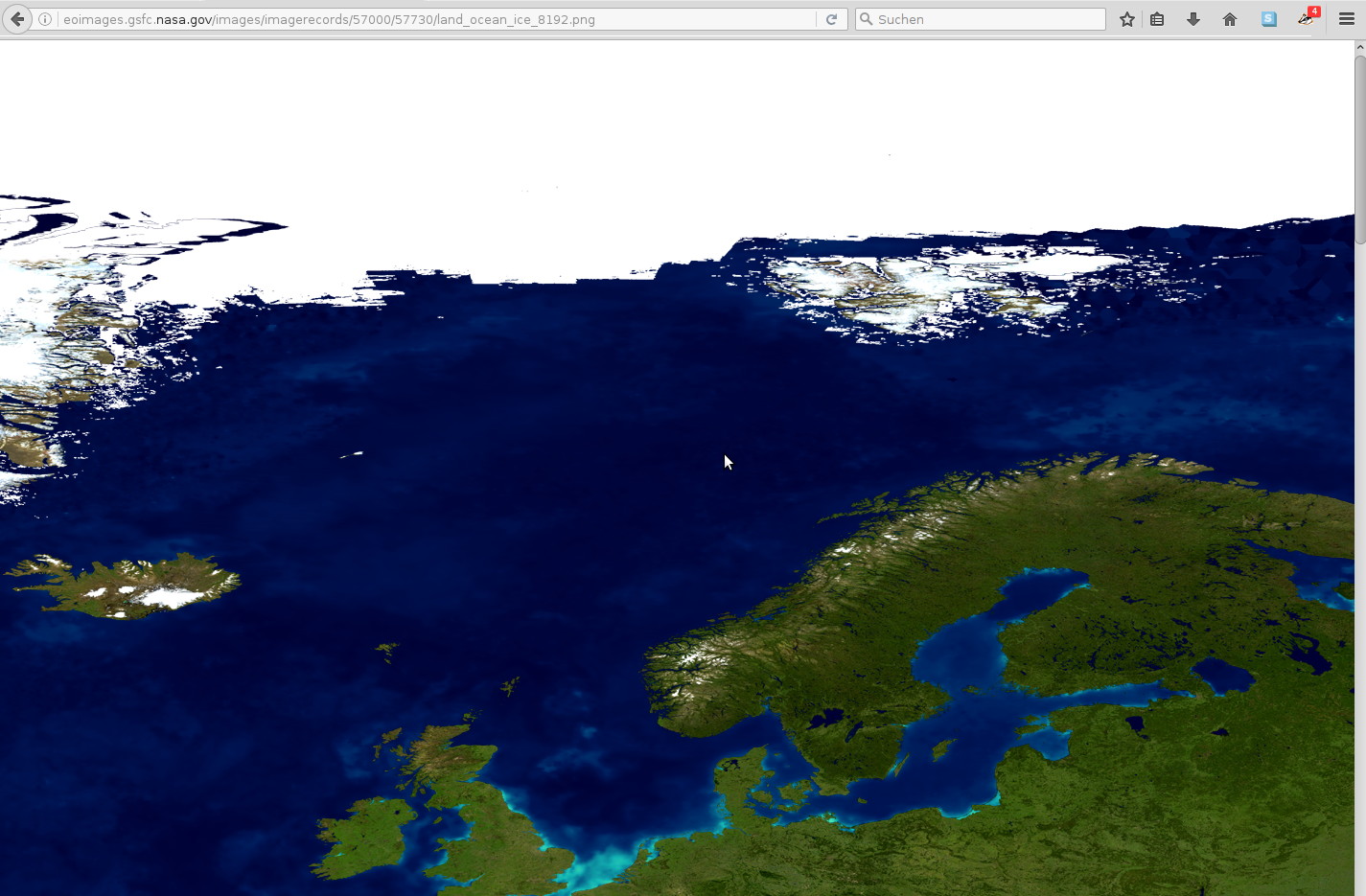
I've taken another look at http://visibleearth.nasa.gov/view.php?id=57730
Looks like they also had their hands full, getting a decent resolution going:
Don't hesitate to let me know if I'm incorrect or just annoying! As long as you do it gently! :)
Debian stable 64bit - i7 8x2.8GHz - 20GB RAM - GeForce GTS 450
Citation II
Debian stable 64bit - i7 8x2.8GHz - 20GB RAM - GeForce GTS 450
Citation II
-
chris_blues - Retired
- Posts: 1577
- Joined: Mon May 03, 2010 2:30 pm
- Location: claws of real life
- Callsign: chris_blues
- Version: GIT
- OS: Debian stable 64
Re: Earthview - an orbital terrain rendering engine [v0.1]
![]() by Thorsten » Wed Nov 02, 2016 6:39 pm
by Thorsten » Wed Nov 02, 2016 6:39 pm
These are 8192x8192 png files. While typing this, these tile-borders come to mind! With the propagated pixels... Let me know, if we need this.
Yikes - you're quick... I'm still busy de-bugging Shuttle for a stable release, just wanted to put this up as an idea!
Anyway - yes, we're going to need the propagated pixels, because the uv-mapping will be shared, so the features on all textures literally need to be on top of each other.
- Thorsten
- Posts: 12490
- Joined: Mon Nov 02, 2009 9:33 am
Re: Earthview - an orbital terrain rendering engine [v0.1]
![]() by chris_blues » Wed Nov 02, 2016 6:41 pm
by chris_blues » Wed Nov 02, 2016 6:41 pm
Ok, then I'll have to get back into the text-editor... That might take little longer. 
Don't hesitate to let me know if I'm incorrect or just annoying! As long as you do it gently! :)
Debian stable 64bit - i7 8x2.8GHz - 20GB RAM - GeForce GTS 450
Citation II
Debian stable 64bit - i7 8x2.8GHz - 20GB RAM - GeForce GTS 450
Citation II
-
chris_blues - Retired
- Posts: 1577
- Joined: Mon May 03, 2010 2:30 pm
- Location: claws of real life
- Callsign: chris_blues
- Version: GIT
- OS: Debian stable 64
Re: Earthview - an orbital terrain rendering engine [v0.1]
![]() by chris_blues » Thu Nov 03, 2016 4:38 pm
by chris_blues » Thu Nov 03, 2016 4:38 pm
Here we go: https://musicchris.de/public_pics/FGear ... s_earth.7z (8k png - ca 100MB)
Possible, that we need a little assistance by someone, who knows more about texturing / normalmaps. I took the heightmaps, added the pixel-propagated borders, and then processed this with "Prewitt 3x3", no additional parameters. I don't know, if I should have used the cropped heightmaps, and add the borders to the normal maps, or if I did it in the right order. Also, the algorythm used - I simply don't know, which would be best for this scenario... So any help would be nice!
If you should notice any artefacts at the texture borders, it'll propably be the order of my processing...
Edit:
Also, I should resize the heightmaps first, before generating the normalmap, in order to get 2k and 4k resolutions, right? I'd guess a simple resize of the normalmaps would result in lost information of the r and g channel...
Don't hesitate to let me know if I'm incorrect or just annoying! As long as you do it gently! :)
Debian stable 64bit - i7 8x2.8GHz - 20GB RAM - GeForce GTS 450
Citation II
Debian stable 64bit - i7 8x2.8GHz - 20GB RAM - GeForce GTS 450
Citation II
-
chris_blues - Retired
- Posts: 1577
- Joined: Mon May 03, 2010 2:30 pm
- Location: claws of real life
- Callsign: chris_blues
- Version: GIT
- OS: Debian stable 64
Who is online
Users browsing this forum: No registered users and 3 guests