I am trying to improve SUAA airport.
Using WED, I've made a first draft and processed the suaa.dat with Airport Web Generator.
After placing the SUAA.btg.gz into my scenery/Terrain folder, I realize that many terrain undulations intersects my taxiways.
Modifying the airport altitude (in WED) does not fix the problem.
I guess that must "flatten" the area first.
Am I wrong?
How to do such task?
Board index ‹ FlightGear ‹ Development ‹ Scenery
How to "iron" a .btg file ?
12 posts
• Page 1 of 1
How to "iron" a .btg file ?
![]() by rleibner » Mon Jan 18, 2021 7:12 pm
by rleibner » Mon Jan 18, 2021 7:12 pm
Rodolfo
*************************
Non-shared knowledge is lost knowledge
*************************
Non-shared knowledge is lost knowledge
-

rleibner - Posts: 269
- Joined: Fri May 19, 2017 8:17 pm
- Location: Uruguay - SUMU
- Callsign: CX-BEX
- Version: next
- OS: Ubuntu 18.04.4
Re: How to "iron" a .btg file ?
![]() by SurferTim » Mon Jan 18, 2021 8:01 pm
by SurferTim » Mon Jan 18, 2021 8:01 pm
What are you using for elevation data? An hgt file?
Fly low. Fly slow. Land on a dime. Twin Otter. https://github.com/SurferTim/dhc6p
My other aircraft is a Citation-X https://github.com/SurferTim/CitationX
PirateAir videos at https://www.youtube.com/user/SurferTim850
My other aircraft is a Citation-X https://github.com/SurferTim/CitationX
PirateAir videos at https://www.youtube.com/user/SurferTim850
-

SurferTim - Posts: 1718
- Joined: Sun Dec 09, 2018 6:49 pm
- Location: Miramar Beach, FL
- Callsign: Pirate
- Version: 2020.4.0
- OS: Ubuntu 18.04
Re: How to "iron" a .btg file ?
![]() by rleibner » Mon Jan 18, 2021 9:27 pm
by rleibner » Mon Jan 18, 2021 9:27 pm
SurferTim wrote in Mon Jan 18, 2021 8:01 pm:What are you using for elevation data? An hgt file?
I did not modified elevations yet (don't know how), but using the original ...TerraSync/Terrain/w060s40/w057s35/2018762.btg
Rodolfo
*************************
Non-shared knowledge is lost knowledge
*************************
Non-shared knowledge is lost knowledge
-
rleibner - Posts: 269
- Joined: Fri May 19, 2017 8:17 pm
- Location: Uruguay - SUMU
- Callsign: CX-BEX
- Version: next
- OS: Ubuntu 18.04.4
Re: How to "iron" a .btg file ?
![]() by D-ECHO » Mon Jan 18, 2021 10:11 pm
by D-ECHO » Mon Jan 18, 2021 10:11 pm
The Airport Web Generator ignores elevation and doesnt cut holes for the airport into the surrounding terrain, as it's just to test your layout. You need to run terragear to generate usable terrain.
- D-ECHO
- Posts: 2462
- Joined: Sat May 09, 2015 1:31 pm
- Pronouns: Bea (she/her)
- Version: next
Re: How to "iron" a .btg file ?
![]() by rleibner » Sat Jan 23, 2021 8:03 pm
by rleibner » Sat Jan 23, 2021 8:03 pm
D-ECHO wrote in Mon Jan 18, 2021 10:11 pm:... You need to run terragear to generate usable terrain.
Honestly, I have tried many times to compile TerraGear. I've never been able to do it, it's beyond my ability.
Will there be another way to do it?
Maybe uploading the project to the X-Plane Airport Gateway ... perhaps some day FGFS will pick the design from there ... ?
Rodolfo
*************************
Non-shared knowledge is lost knowledge
*************************
Non-shared knowledge is lost knowledge
-
rleibner - Posts: 269
- Joined: Fri May 19, 2017 8:17 pm
- Location: Uruguay - SUMU
- Callsign: CX-BEX
- Version: next
- OS: Ubuntu 18.04.4
Re: How to "iron" a .btg file ?
![]() by SurferTim » Sun Jan 24, 2021 1:16 pm
by SurferTim » Sun Jan 24, 2021 1:16 pm
rleibner wrote in Sat Jan 23, 2021 8:03 pm:D-ECHO wrote in Mon Jan 18, 2021 10:11 pm:... You need to run terragear to generate usable terrain.
Honestly, I have tried many times to compile TerraGear. I've never been able to do it, it's beyond my ability.
Will there be another way to do it?
It was for me too until today. I tried to build TerraGear a couple years back with no luck.
I read your post this morning, and tried compiling TerraGear with the download_and_compile.sh script.
http://wiki.flightgear.org/Scripted_Com ... ian/Ubuntu
- Code: Select all
mkdir -p ~/flightgear
cd ~/flightgear
git clone https://git.code.sf.net/p/flightgear/fgmeta
After the clone,, I used this
- Code: Select all
cd ./flightgear/fgmeta
./download_and_compile.sh -j4 TERRAGEAR
It compiled great. Looks like I may be in the scenery business soon.
Edit: My bad. Shoulda tested it first. It didn't compile.
It apparently failed when attempting to link genapts850
Fly low. Fly slow. Land on a dime. Twin Otter. https://github.com/SurferTim/dhc6p
My other aircraft is a Citation-X https://github.com/SurferTim/CitationX
PirateAir videos at https://www.youtube.com/user/SurferTim850
My other aircraft is a Citation-X https://github.com/SurferTim/CitationX
PirateAir videos at https://www.youtube.com/user/SurferTim850
-
SurferTim - Posts: 1718
- Joined: Sun Dec 09, 2018 6:49 pm
- Location: Miramar Beach, FL
- Callsign: Pirate
- Version: 2020.4.0
- OS: Ubuntu 18.04
Re: How to "iron" a .btg file ?
![]() by rleibner » Mon Jan 25, 2021 4:20 pm
by rleibner » Mon Jan 25, 2021 4:20 pm
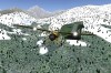
This is how SUAA airport is seen according TerraSync:

and this is how it must be seen:

Unfortunately, cause the terrain elevations, I actually have:

Note: All streets and buildings (except the tower) are from OSM.
Other details are gathered from the AIP and on site observation.
and this is how it must be seen:
Unfortunately, cause the terrain elevations, I actually have:
Note: All streets and buildings (except the tower) are from OSM.
Other details are gathered from the AIP and on site observation.
Rodolfo
*************************
Non-shared knowledge is lost knowledge
*************************
Non-shared knowledge is lost knowledge
-
rleibner - Posts: 269
- Joined: Fri May 19, 2017 8:17 pm
- Location: Uruguay - SUMU
- Callsign: CX-BEX
- Version: next
- OS: Ubuntu 18.04.4
Re: How to "iron" a .btg file ?
![]() by rleibner » Mon Jan 25, 2021 9:00 pm
by rleibner » Mon Jan 25, 2021 9:00 pm
SurferTim wrote: ... Shoulda tested it first. It didn't compile....
One wish:
It would be great if someone were working to create a Terragear.AppImage
Am I dreaming too much?
Rodolfo
*************************
Non-shared knowledge is lost knowledge
*************************
Non-shared knowledge is lost knowledge
-
rleibner - Posts: 269
- Joined: Fri May 19, 2017 8:17 pm
- Location: Uruguay - SUMU
- Callsign: CX-BEX
- Version: next
- OS: Ubuntu 18.04.4
Re: How to "iron" a .btg file ?
![]() by Fahim Dalvi » Tue Jan 26, 2021 6:48 am
by Fahim Dalvi » Tue Jan 26, 2021 6:48 am
Not an AppImage, but terragear does have a nice docker image to avoid the compilation hassle! I also wrote a small article to help people get started: http://wiki.flightgear.org/User:Fahim_D ... ing_Docker
Hope this helps!
Hope this helps!
-
Fahim Dalvi - Posts: 1353
- Joined: Sun Oct 14, 2007 2:08 pm
- Location: Qatar
- Callsign: Fahim
- Version: 2020.3.11
- OS: macOS
Re: How to "iron" a .btg file ?
![]() by rleibner » Wed Jan 27, 2021 5:30 pm
by rleibner » Wed Jan 27, 2021 5:30 pm
Fahim Dalvi wrote in Tue Jan 26, 2021 6:48 am:Not an AppImage, but terragear does have a nice docker image ...
Thanks for your help.
I followed the steps and have now a lot of .fit.gz files, among them the only tile I need:
- Code: Select all
flightgear@6672f7968f1d:/terragear-work/ work/SRTM-3> ls w060s40/w057s35/2018762.*
w060s40/w057s35/2018762.arr.gz   w060s40/w057s35/2018762.fit.gz
From here I'm confused. Please note that I try to edit only the terrain heights on that tile (keeping untouched the landclass ...)
Briefly I have:
- the w060s40/w057s35/2018762.fit.gz file
- the SUAA.dat generated by WED & Flightgear Airport Web
- and all the 2018762.stg files provided by TerraSync
How must I process al together ?
Rodolfo
*************************
Non-shared knowledge is lost knowledge
*************************
Non-shared knowledge is lost knowledge
-
rleibner - Posts: 269
- Joined: Fri May 19, 2017 8:17 pm
- Location: Uruguay - SUMU
- Callsign: CX-BEX
- Version: next
- OS: Ubuntu 18.04.4
Re: How to "iron" a .btg file ?
![]() by xDraconian » Thu Jan 28, 2021 5:29 am
by xDraconian » Thu Jan 28, 2021 5:29 am
- xDraconian
- Posts: 406
- Joined: Sun Jan 21, 2018 6:53 am
- Version: Git
- OS: Linux Mint
Re: How to "iron" a .btg file ?
![]() by J-ROME » Fri Feb 05, 2021 9:01 am
by J-ROME » Fri Feb 05, 2021 9:01 am
Hi,
I have been searching for a while too....
here is how I have done for the DZ Les Bois in Chamonix 45.939011145739, 6.895890242314685
srtmchop DATA/SRTM/srtm_38_03/srtm_38_03.tif work/SRTM-3
terrafit -m 50 -x 4000 -e 2 work/SRTM-3
ogr-decode --max-segment 500 --spat 6.75 45.875 7 46 --area-type Default work/Landmass landmass/v0_landmass-master
genapts850 --input=./data/airports/DZCHAM.dat --work=./work
tg-construct --priorities=/usr/local/share/TerraGear/default_priorities.txt --work-dir=./work --output-dir=./output/Terrain --min-lon=6.75 --max-lon=7 --min-lat=45.875 --max-lat=46 AirportArea AirportObj Landmass SRTM-3
no need to bother too ;uch with .shp since I am using Orthophotos.
Cheers
Those who by vanity attempt climbs beyond their capabilities… dismiss easily the risks taken by their rescuers.
-

J-ROME - Posts: 24
- Joined: Sat Dec 26, 2020 2:22 am
- Callsign: J-ROME
- Version: nightly
- OS: Debian Bookworm
12 posts
• Page 1 of 1
Who is online
Users browsing this forum: No registered users and 4 guests